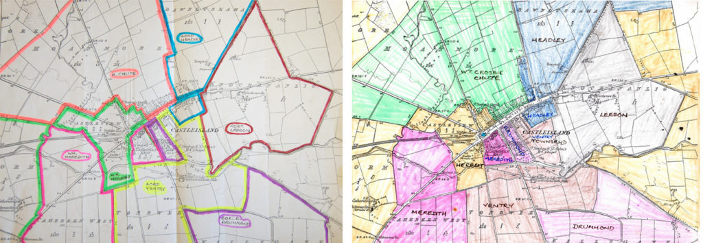
Michael O’Donohoe approached the ordnance survey map of the Castleisland district in a creative way to help discern, at a glance, who owned what and where in the nineteenth century.
It is a very useful guide for anyone interested in history and genealogy or for those new to research who want to understand the make-up of barony, parish and townland.1

Trughanacmy, the baronial home of Castleisland, was of particular interest. A description of the barony is held in IE MOD 4.4.
Michael also illustrated the map of the town of Castleisland in colour to give a visual representation of the estates of landed proprietors in the nineteenth century.2
___________________
1 IE MOD 50-50.1-50.1.1. The names of the baronies are in black ink in the surrounding areas of the map.  Within the baronies are the civil parishes outlined and numbered, again in black: 0-7. The numbers represent the following parishes: 1 Castleisland; 2 Ballincushlane, Killeentierna and Dysert; 3 Brosna; 4 O'Brennan; 5 Ballymacelligott; 6 Nohoval; 7 Currans; 0 Tralee.  The parishes, composed of differing numbers of townlands, have been colour coded with the names of nineteenth century landlords.  The system devised was this: Yellow: Headley; Green: Chute; Orange: Leeson; Blue: Drummond; Brown: Ventry; Purple: Herbert; Red: Meredith; Pink: Bateman.  See also IE MOD/4.4.  This series also contains Ordnance Survey map Sheets 39 and 40 published in 1969.
2 IE MOD/51. Series also contains one full scale contemporary Ordnance Survey map of Main Street, Castleisland and one A3 copy of a Site Appraisal Castleisland Area Services Centre map (O’Sullivan Campbell Architects) which illustrates the proposed development of the Castleisland library site.


